OpenMadeira
Tell me about the Água de Pena - Ponta de São Lourenço hike in Madeira
💭 Thinking
The user is asking about the "Água de Pena - Ponta de São Lourenço" hike in Madeira. This sounds like it could be an official PR trail or a community trail. Let me search for it using find_hikes.The search returned no results for "Água de Pena - Ponta de São Lourenço". Let me try a broader search, maybe searching for "São Lourenço" or "Ponta de São Lourenço" which is the more common way to refer to this trail.I found the official PR 8 - Vereda da Ponta de S. Lourenço. This is the trail the user is asking about ("Água de Pena - Ponta de São Lourenço"). Let me also check the current status of this trail since the note says status is deliberately omitted for evergreen pages. Wait, the result shows `"status":""` which means it's empty. Let me check the current status separately.The user asked about "Água de Pena - Ponta de São Lourenço". This isn't matching an official PR trail name exactly. The official trail for Ponta de São Lourenço is PR 8 - "Vereda da Ponta de S. Lourenço". "Água de Pena" is a parish/area near Machico - it could refer to an alternative starting point or a community trail variant. Let me check if the user might be referring to a community trail. The first search returned community trails near Ponta de São Lourenço but none named "Água de Pena - Ponta de São Lourenço" specifically. The second search found PR 8 - the official Ponta de São Lourenço trail. "Água de Pena" is a civil parish in the municipality of Machico. It's possible the user is thinking of a route that starts from Água de Pena and goes towards Ponta de São Lourenço. This could be a community/unofficial trail, or it could be that the user is referring to PR 8 with an alternative name. Since there's no official PR trail with "Água de Pena" in the name, the closest match is PR 8 - Vereda da Ponta de S. Lourenço. The trail starts at Baía D'Abra (which is near Caniçal, in the Caniçal parish, part of the Machico municipality area, but not from Água de Pena specifically). Let me search for "Água de Pena" specifically in the community trails to see if there's one.The user is asking about the "Água de Pena - Ponta de São Lourenço" hike. Let me analyze: 1. There's no official PR trail called "Água de Pena - Ponta de São Lourenço" in the results. 2. The closest official trail is **PR 8 - Vereda da Ponta de S. Lourenço**, which starts at Baía d'Abra and goes to Cais do Sardinha (Casa do Sardinha). It's about 15.2 km / 17 minutes drive from Água de Pena. 3. There could be a community trail with that name, but it doesn't appear in the results either. The user likely means the PR 8 Vereda da Ponta de São Lourenço — the famous hike on the eastern peninsula. "Água de Pena" is a parish nearby, and Ponta de São Lourenço is the peninsula. The trail doesn't start from Água de Pena itself; it starts from Baía d'Abra. Let me also check if there's a video I can show for this trail. The trail data I have for PR 8: - PR code: PR 8 - Name: Vereda da Ponta de S. Lourenço - Route: Baía D'Abra – Cais do Sardinha - Distance: 4 km (+ 4 km return) - Difficulty: Moderate - Duration: 2:30 hours - Start point: Baía d'Abra - End point: Casa do Sardinha - Max altitude: 126 m - Min altitude: 23 m - Access fee: €4.50 (visitors > 12 years), free for ≤ 12 years, via SIMplifica portal - Managing entity: IFCN - AllTrails: 4.7★ from 8,379 reviews - Drive from Água de Pena: 15.2 km, 17 min - YouTube video: 22TqiShcn1w - Webcam: Caniçal webcam available - Status: The status field is empty, meaning I should not state a status (the note says it's deliberately omitted for the evergreen guide). But the user asked "tell me about" this hike, not specifically about its current status, so I should note they should check the current status. Wait, actually the note says "Do NOT state any open/closed/restricted status — it is DELIBERATELY omitted here because it changes over time and this page is cached." But this is a live question, not a static page. Let me check again... Actually, looking at the hike results, the `status` field is empty (""). The note at the bottom is for generating an evergreen/static page. For a live user question, I should ideally be providing current status info. Since the status is empty, I can't state one. I should direct them to check current status. Let me compose a comprehensive answer about PR 8 Vereda da Ponta de São Lourenço, noting that the trail starts at Baía d'Abra (not from Água de Pena itself, though Água de Pena is nearby). I should also embed the YouTube video since there's a YouTubeID available.
How this was derived · 3 steps
Trails near Água de PenaMap & photos
Vereda da Ponta de S. Lourenço6 photos
Vereda da Ponta de S. LourençoVereda da Ponta de S. LourençoVereda da Ponta de S. LourençoVereda da Ponta de S. LourençoVereda da Ponta de S. LourençoVereda da Ponta de S. Lourenço
Official PR trail (IFCN) Community route (AllTrails — not official)
Photos: walkmeguide.com · green = official IFCN PR trail · amber = community route (AllTrails)
Vereda da Ponta de S. Lourenço (PR 8)

There isn't an official PR trail specifically called "Água de Pena – Ponta de São Lourenço," but the hike you're referring to is almost certainly PR 8 — Vereda da Ponta de S. Lourenço, Madeira's iconic eastern-peninsula trail. Água de Pena is the nearby parish — the trailhead is at Baía d'Abra, about a 17-minute drive from Água de Pena.


Key facts
Official nameVereda da Ponta de S. Lourenço
PR codePR 8
Managed byIFCN (regional forests & nature authority)
DifficultyModerate
Distance4 km one way (+ 4 km return)
Duration~2 h 30 min
RouteBaía d'Abra → Casa do Sardinha
Altitude range23 m – 126 m
TypeOut and back
Access fee€4.50 (visitors > 12 years), free for children ≤ 12, paid via the SIMplifica portal
What to expect

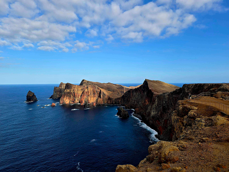
This is one of Madeira's most dramatic and popular hikes. The trail follows the Ponta de São Lourenço peninsula — a narrow finger of land jutting out into the Atlantic on the island's eastern tip. The landscape is starkly different from the lush north: golden and reddish volcanic cliffs, sparse vegetation, and sweeping ocean views on both sides. You'll pass several viewpoints overlooking sheer drops to the sea, and if conditions are right, you can spot the Desertas Islands to the southeast.

The path ends at Cais do Sardinha (Casa do Sardinha), where a small lighthouse stands. The return is along the same route.

Community rating: 4.7★ from 8,379 hiker reviews on AllTrails — one of the island's most popular trails (AllTrails page ↗)

Getting there from Água de Pena
  • Driving: ~15 km / 17 min to the trailhead at Baía d'Abra — Directions ↗
  • There's a car park at Baía d'Abra, but it fills up quickly on busy days.
Practical tips
  • No shade — bring sun protection and plenty of water, especially in summer.
  • Check the wind — the exposed ridge can be very windy; avoid the trail in strong winds.
  • Footwear — the path has some uneven, rocky sections; proper hiking shoes are recommended.
  • Current status — check the trail's open/closed status before setting out, as conditions can change.

Watch: Vereda da Ponta de São Lourenço

Photos: walkmeguide.com · Visit Madeira ↗

Would you like me to check the mountain forecast and IPMA warnings for the day you plan to go?

OpenMadeira can make mistakes — check the sources.