OpenMadeira
Tell me about the Circuit of Boca do Risco and Pico Furado hike in Madeira
💭 Thinking
The user is asking about the "Circuit of Boca do Risco and Pico Furado" hike in Madeira. Let me search for this trail using find_hikes.The search for "Boca do Risco Pico Furado" didn't return results directly. Let me try searching with the specific PR code or a different query. This trail is likely PR 10 - Levada do Caniço / Boca do Risco, or it could be a community trail. Let me searchmore specifically.The user is asking about the "Circuit of Boca do Risco and Pico Furado" hike in Madeira. From the search results, this is NOT an official IFCN PR trail — it appears in the community trails as "Rota das Veredas da Boca do Risco e Larano" and related routes. Let me focus on the most relevant community trails. The closest matches are: 1. **Rota das Veredas da Boca do Risco e Larano** — 10.1 km, point to point, hard, 4.7★ (180 reviews) 2. **Vereda Boca do Risco Caniçal - Levada do Caniçal** — 14.6 km, loop, hard, 4.7★ (168 reviews) 3. **Rota da Boca do Risco - Levada do Caniçal** — 13.5 km, loop, hard, 4.5★ (106 reviews) The "Circuit of Boca do Risco and Pico Furado" name most specifically refers to a route that goes through Boca do Risco and passes Pico do Furado. Looking at the community trails, the one that most closely matches "Boca do Risco and Pico Furado" would be the Rota das Veredas da Boca do Risco e Larano, or possibly the Vereda Boca do Risco Caniçal - Levada do Caniçal which starts near Caniçal. Actually, "Pico Furado" is a specific peak/landmark. The PR 8 (Vereda da Ponta de S. Lourenço) AllTrails page is actually titled "Miradouro de São Lourenço - Cais do Sardinha - Pico do Furado" — and Pico do Furado is a peak along the Ponta de São Lourenço peninsula route. So the "Circuit of Boca do Risco and Pico Furado" likely refers to a community/unofficial route that combines the Boca do Risco section with Pico Furado. From the community trails data, the most relevant one that explicitly mentions "Boca do Risco" is: - **Rota das Veredas da Boca do Risco e Larano** — 10.1 km, point to point, hard, 4.7★ from 180 reviews This is a community route (not an official IFCN PR trail), so I need to label it clearly as such. Let me provide a comprehensive answer about this trail.
How this was derived · 2 steps
Trails near MachicoMap & photos
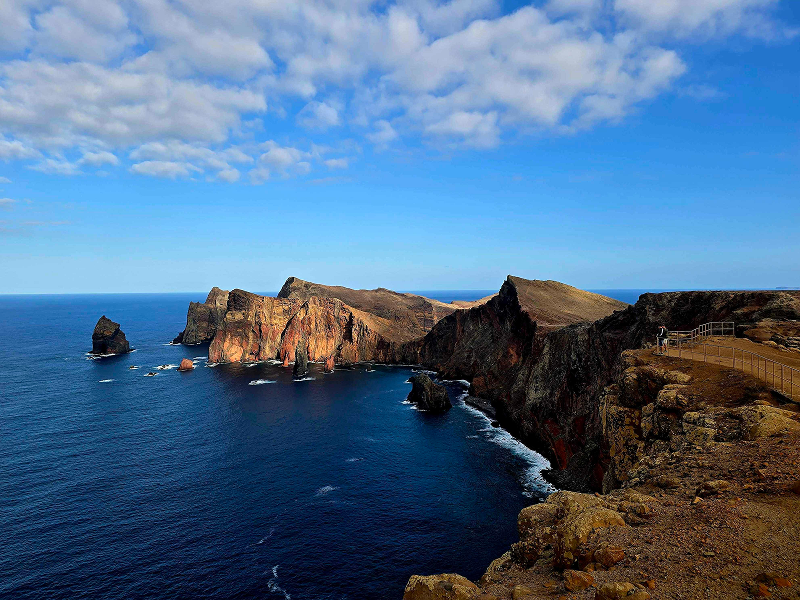
Vereda da Ponta de S. Lourenço6 photos
Vereda da Ponta de S. LourençoVereda da Ponta de S. LourençoVereda da Ponta de S. LourençoVereda da Ponta de S. LourençoVereda da Ponta de S. LourençoVereda da Ponta de S. Lourenço
Official PR trail (IFCN) Community route (AllTrails — not official)
Photos: walkmeguide.com · green = official IFCN PR trail · amber = community route (AllTrails)
Circuit of Boca do Risco and Pico Furado

This is a community-mapped route on AllTrails — it is not part of Madeira's official PR trail network managed by IFCN (the regional government's forests and nature-conservation authority), so it has no official open/closed status or maintained signage. Check access and conditions locally before setting out.


Rota das Veredas da Boca do Risco e Larano

The trail most closely matching your description is the Rota das Veredas da Boca do Risco e Larano — a stunning coastal path on Madeira's eastern side.

Length10.1 km
Route typePoint to point
DifficultyHard
Estimated time~6–7 hours
Community rating4.7★ from 180 hiker reviews on AllTrails
AreaMadeira Natural Park

Route description: The trail starts at the Casa dos Levadeiros and follows the Vereda da Boca do Risco – Larano. You walk through agricultural fields and small exotic forests until you reach Boca do Risco, one of the most beautiful natural viewpoints on the island's east side, with sweeping Atlantic coastal views. From there, you can head towards Caniçal or Porto da Cruz. The path towards Larano is breathtaking but can be risky in some areas and requires extra caution — sections are narrow and exposed along the cliff edge.

⚠️ Important: This is an unofficial community route, not an IFCN-managed PR trail. There is no official open/closed status, no maintained signage, and no guarantee of trail conditions. Sections near Larano are exposed and potentially dangerous — not recommended in wet or windy weather.

Directions to the trailhead ↗


Related Boca do Risco routes

Several other community routes explore the same area:

RouteLengthTypeRatingAllTrails
Vereda Boca do Risco Caniçal – Levada do Caniçal14.6 kmLoop4.7★ (168)link ↗
Rota da Boca do Risco – Levada do Caniçal13.5 kmLoop4.5★ (106)link ↗
Caniçal's Levada – Larano Footpath26.6 kmOut & back4.7★ (398)link ↗

All are community routes (not official IFCN PR trails) with no official open/closed status.


Nearby official PR trail

The closest official IFCN trail is PR 8 – Vereda da Ponta de S. Lourenço (which passes Pico do Furado on the eastern peninsula), about 15 minutes' drive away. It's a moderate 8 km out-and-back (4 km + 4 km return), 2½ hours, managed by IFCN, with a €4.50 access fee for visitors over 12. 4.7★ from nearly 8,000 reviews on AllTrails.


Would you like me to check the mountain weather forecast and IPMA warnings for the day you're planning to hike, or find how to get to the trailhead by bus?

OpenMadeira can make mistakes — check the sources.