OpenMadeira
Tell me about the Ilha - Santana hike in Madeira
💭 Thinking
The user is asking about the "Ilha - Santana" hike in Madeira. This sounds like it could be a trail. Let me search for it using the find_hikestool.The search returned 0 results for "Ilha Santana". Let me try different search terms - maybe "PR 27" or just "Ilha" near Santana, or "Santana" as a query.I found the trail. The user asked about "Ilha - Santana" hike, which matches the official PR 1.1 "Vereda da Ilha". Let me compile the details from the results. Key details from the tool result: - PR code: PR 1.1 - Name: Vereda da Ilha - Route: Pico Ruivo – Ilha - Distance: 8.2 km - Difficulty: Moderate (official IFCN) / Hard (AllTrails community) - Duration: 3 hours (official) - Start point: Casa de Abrigo do Pico Ruivo - End point: Ilha - Max altitude: 1,764 m - Min altitude: 490 m - Access fee: €4.50 for visitors > 12 years, exempt for ≤ 12 years, parking €2.00/hour (via SIMplifica portal) - Managing entity: IFCN - AllTrails: 4.6★ from 174 reviews - Near Santana: 6.7 km drive, ~12 minutes Note: The status field is empty in the result, and there's a note saying this is an evergreen guide and not to state open/closed status. But I should still tell the user to check current status. Actually, looking at the instructions more carefully: "ALWAYS state the trail's STATUS (open / closed / restricted) — lead with it". However, the tool result has an empty status field, and the note says "Do NOT state any open/closed/restricted status — it is DELIBERATELY omitted here because it changes over time and this page is cached." Wait, this is confusing. The main system prompt says to always state the trail's status, but the tool result's note says not to state status for evergreen pages. Since this is a direct user question (not a static page), I should check the current status. Let me make a note to tell the user to check current status. Actually, re-reading the note in the tool result - it seems like this is context for building a static page. For a live user query, I should check the current trail status. But the status field is empty in the result. Let me look again... The status is empty string "". The system prompt says "ALWAYS state the trail's STATUS (open / closed / restricted)" and "If no tool/source has it, say so honestly." Since the status is empty (not provided), I should note that I don't have the current status and direct the user to check. Wait, let me re-read: the note says "This is an EVERGREEN trail guide for a static page. Do NOT state any open/closed/restricted status — it is DELIBERATELY omitted here because it changes over time and this page is cached." This seems like metadata for a different use case (building a static page). For the user's interactive query, I should still try to give them useful info about status. But the data simply doesn't include status. I'll note that status should be checked and move on. Let me compose a good answer about Vereda da Ilha (PR 1.1).
How this was derived · 1 step
Trails near SantanaMap & photos
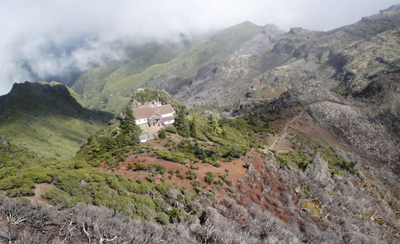
Vereda da Ilha6 photos
Vereda da IlhaVereda da IlhaVereda da IlhaVereda da IlhaVereda da IlhaVereda da Ilha
Official PR trail (IFCN) Community route (AllTrails — not official)
Photos: walkmeguide.com · green = official IFCN PR trail · amber = community route (AllTrails)
Vereda da Ilha (PR 1.1) — Santana

Vereda da Ilha is an official PR trail in the Santana municipality that descends from Madeira's highest peak all the way down to the village of Ilha on the north coast. It's one of the most dramatic routes on the island — a long, mostly downhill walk through changing landscapes, from barren mountain ridges to lush laurel forest and cultivated terraces.

Key facts
PR codePR 1.1
RoutePico Ruivo → Ilha
Distance8.2 km
Duration~3 h (official)
DifficultyModerate (official IFCN)
StartCasa de Abrigo do Pico Ruivo (1,764 m)
EndIlha (490 m)
Altitude range1,764 m → 490 m
Managed byIFCN
Access fee€4.50 (visitors > 12 yrs) / free (≤ 12 yrs) — via SIMplifica portal. Parking: €2.00/hr

⚠️ Check current trail status before setting out — trail conditions (open/closed/restricted) change over time. Verify the latest status on OpenMadeira.

The route

You start at the Casa de Abrigo do Pico Ruivo shelter — the same trailhead as the famous Pico Ruivo summit hikes. From there the path heads north, descending steadily through high mountain terrain with panoramic views down to the sea on both sides. As you drop in altitude the vegetation shifts from exposed shrubland to dense laurissilva (laurel forest), and eventually opens out onto the terraced farmland around Ilha. The total descent is over 1,270 m, so while it's rated moderate, it's physically demanding on the knees and joints — many hikers arrange transport back up rather than walking the return.

Community rating

4.6 / 5 from 174 hiker reviews on AllTrails — hikers highlight the spectacular views contrasting the high peaks with the coast, and the rewarding variety of landscapes as you descend.

Getting to the trailhead

From Santana, the drive to the Pico Ruivo trailhead is approximately 6.7 km / ~12 min. Use Directions ↗ to route from your location.

Practical tips
  • Start early — the trail is exposed at the top, and afternoon mist is common on the north coast.
  • Arrange a pick-up or taxi at Ilha — the return climb of 1,270 m is brutal; most walkers don't do the round trip.
  • Wear knee-supportive footwear — the long descent is tough on joints.
  • Bring layers — at 1,764 m it can be cold and windy; by the time you reach Ilha you'll be in warm coastal air.

Would you like me to check the mountain weather forecast and IPMA warnings for the day you're planning to hike, or show you how to get to the trailhead by bus?

OpenMadeira can make mistakes — check the sources.