OpenMadeira
Tell me about the Levada do Alecrim - Pico da Urze Dam levada walk in Madeira
💭 Thinking
The user is asking about the "Levada do Alecrim - Pico da Urze Dam" levada walk in Madeira. Let me look this up using the find_hikes tool to get official information about this trail.The search for "Levada do Alecrim Pico da Urze" returned no results from the official PR trail database. This trail might be a community/unofficial trail, or it might be listed under a different name. Let me try searching with different terms. Let me also try searching for "Alecrim" alone, and also check if this is a known trail on AllTrails but not an official PRtrail.Now I have good information about the Levada do Alecrim - Pico da Urze Dam trail. Let me organize the key facts: The user asked about "Levada do Alecrim - Pico da Urze Dam" - this is a community route from AllTrails, not an official PR trail. It appears in the `community_trails` results: From AllTrails: - Name: "Levada do Alecrim - Pico da Urze Dam" - Rating: 4.5 / 5 - Reviews: 175 - Difficulty: moderate - Length: 10.5 km - Route type: out and back - Estimated time: 3–3.5 hr - Description: "This route runs along a section of the Alecrim levada, starting and finishing near the Chapel of Fátima, and leads to the Dona Beja lagoon. On the way back, the route also passes the Pico da Urze dam. It's a pleasant route through dense forest, with a few waterfalls where you can cool off on a hot day." - Location: Madeira Natural Park - Lat/Lng: 32.75462, -17.13359 There's also a related community trail called "Ovil - Levada do Alecrim - Levada do Pico da Urze" which is a 4.2 km loop. And the official PR 6.2 - Levada do Alecrim is also in the area. Importantly, this is NOT an official PR trail - it's a community/unofficial route. I need to label it as such. Let me also check for current trail status. Since this is not an official IFCN PR trail, there's no official open/closed status. I should mention that. The official PR 6.2 Levada do Alecrim: - Distance: 3.5 km (+ 3.5 km return) - Difficulty: Easy - Duration: 2:30 hours - Start: Rabaçal (E.R. 105) - End: Water spring of Levada do Alecrim (Lagoa 'Dona Beja') - Max altitude: 1339 m - Min altitude: 1256 m - Access fee: €4.50 (visitors > 12 years), exempt for ≤ 12 years (via SIMplifica) - AllTrails: 4.6★ from 1719 reviews Now let me compose the answer. The user specifically asked about "Levada do Alecrim - Pico da Urze Dam levada walk" which maps to the AllTrails community route of that name. I should describe it, note it's unofficial, and also mention the related official PR 6.2 for context. Let me also find a video of thetrail.I now have comprehensive information about the Levada do Alecrim - Pico da Urze Dam walk. Let me organize this. The user is asking specifically about the "Levada do Alecrim - Pico da Urze Dam" walk. This is a community/unofficial route on AllTrails, not an official IFCN PR trail. The official PR trail in this area is **PR 6.2 - Levada do Alecrim**. From the AllTrails community data, the specific route "Levada do Alecrim - Pico da Urze Dam" has: - Rating: 4.5★ from 175 reviews - Difficulty: moderate - Length: 10.5 km - Route type: out and back - Estimated time: 3–3.5 hr - It runs along the Alecrim levada, starts/finishes near the Chapel of Fátima, leads to the Dona Beja lagoon, and on the way back passes the Pico da Urze dam. And the official PR 6.2 Levada do Alecrim: - Difficulty: Easy (IFCN) / Moderate (AllTrails) - Distance: 3.5 km (+ 3.5 km return) = 7 km total - Duration: 2:30 hours - Start: Rabaçal (E.R. 105) - End: Water spring of Levada do Alecrim (Lagoa 'Dona Beja') - Max altitude: 1339m, Min: 1256m - Access fee: €4.50 (visitors >12 years), exempt for ≤12 years - AllTrails rating: 4.6★ from 1,719 reviews There's also the "Ovil - Levada do Alecrim - Levada do Pico da Urze" which is a different route (4.2 km loop, rated 4.4★). Let me compose a comprehensive answer about the specific route the user asked about, which is the "Levada do Alecrim - Pico da Urze Dam" out-and-back route, while also mentioning the official PR 6.2 and related trails. Now, regarding the status - the official PR 6.2 is managed by IFCN and requires a fee. The community route that extends to Pico da Urze Dam is not an official PR trail, so it has no official open/closed status. Let me write this up properly.
How this was derived · 6 steps
TrailsMap & photos
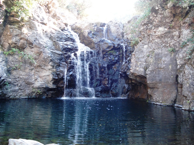
Levada do Alecrim6 photos
Levada do AlecrimLevada do AlecrimLevada do AlecrimLevada do AlecrimLevada do AlecrimLevada do Alecrim
Official PR trail (IFCN) Community route (AllTrails — not official)
Photos: walkmeguide.com · green = official IFCN PR trail · amber = community route (AllTrails)
Levada do Alecrim – Pico da Urze Dam

The walk you're asking about combines the Levada do Alecrim with a stretch to the Pico da Urze Dam (Barragem do Pico da Urze). It's an extended version of the official PR 6.2 that adds the dam on the return. Here's what you need to know:


The official core: PR 6.2 – Levada do Alecrim
DifficultyEasy (IFCN)
Distance3.5 km one way → 7 km round trip
Duration~2 h 30 min
StartRabaçal (ER 105)
EndLagoa Dona Beja (water spring)
Altitude1 256 m – 1 339 m
Managing bodyIFCN
Access fee€4.50 (visitors > 12 years) via SIMplifica · exempt ≤ 12 years
Community rating★ 4.6 from 1 719 hiker reviews on AllTrails

The trail follows the levada through laurisilva forest and heather tunnels to the beautiful Lagoa Dona Beja — a small mountain lake fed by a waterfall, where many hikers turn back. No tunnels on this trail.


The extended route to Pico da Urze Dam

The "Levada do Alecrim – Pico da Urze Dam" route continues past Lagoa Dona Beja to the Barragem do Pico da Urze, the reservoir you may have spotted from the ER 105 road on the drive up.

DifficultyModerate
Distance10.5 km (out & back)
Duration~3 – 3.5 h
Route typeOut and back
Community rating★ 4.5 from 175 reviews on AllTrails

The walk starts and finishes near the Capela de Fátima (Chapel of Fátima) by the ER 105 parking area, follows the Levada do Alecrim through dense forest with several small waterfalls, reaches the Dona Beja lagoon, and then continues to the Pico da Urze dam on the way back. It's a pleasant forest walk with a few waterfalls where you can cool off on a hot day.

⚠️ This extended route is a community-mapped trail on AllTrails — it is NOT part of the official IFCN PR trail network, so it has no official open/closed status and no maintenance guarantee. Check local conditions before setting out.


Getting there

The trailhead is on the ER 105 road in the Rabaçal / Paul da Serra area, the same parking area used for the famous 25 Fontes and Risco trails. There is no public bus service — a rental car or taxi is the practical way to reach it.

Directions to the trailhead ↗


What you'll see along the way
  • Heather tunnels — the path passes through striking corridors of Erica arborea (tree heather)
  • Views over Ribeira Grande valley — gaps in the forest open up to dramatic valley panoramas
  • Lagoa Dona Beja — a serene mountain lagoon fed by a waterfall, the highlight at the half-way point
  • Pico da Urze Dam — the reservoir on the Paul da Serra plateau, visible from the approach road
  • Endemic flora — Madeiran orchid (Dactylorhiza foliosa) in spring, giant sow thistles, and UNESCO-listed laurisilva

Practical tips
  • Go early — the shared Rabaçal parking fills up quickly, especially in summer
  • No tunnels on this route (unlike 25 Fontes), so a headlamp isn't needed
  • Altitude — above 1 200 m, fog is common and temperatures can be 10 °C cooler than Funchal
  • Slippery after rain — levada paths get muddy year-round; proper footwear is essential
  • The fee (€4.50) covers the IFCN-managed PR 6.2 section; the dam extension may not be gated

Also in the area

The Rabaçal zone is a hiking hub — from the same parking you can also do:

TrailDistanceRatingHighlights
PR 6 – Levada das 25 Fontes11 km★ 4.6 (1 719 reviews)25 natural springs & waterfall
PR 6.1 – Levada do Risco2 kmEasyTwo-tier Risco waterfall
PR 6.3 – Vereda da Lagoa do Vento~7 km★ 4.6 (1 719 reviews)Lagoa do Vento waterfall pool

Many hikers combine Levada do Alecrim + Lagoa do Vento for a rewarding half-day loop.

Would you like me to check the mountain weather forecast and IPMA warnings for the day you're planning to go, or find the closest official trails near your accommodation?

OpenMadeira can make mistakes — check the sources.