💭 Thinking
How this was derived · 3 steps


- Levada do Caniço 4.2 Directions
- Caniço Levada Trail (Camacha) 3.7 Directions
- Camacha - Levada Dos Tornos 4.1 Directions
Now I have all the information I need. Let me compile the answer about these three related levada walks. The user asked about "Levada do Caniço - Levada dos Tornos - Ribeirinha" which are three interconnected/related levada walks near Camacha and Caniço in the municipality of Santa Cruz.
Here's what I found:
1. PR 29 – Levada dos Tornos (Camacha) — the OFFICIAL PR trail (partially open), 13 km, moderate, 4–5h
2. Levada do Caniço — community/unofficial trail on AllTrails, 8.7 km, moderate, 3–3.5h
3. Caniço Levada Trail (Camacha) — community/unofficial trail on AllTrails that connects Camacha to Caniço along the Levada do Caniço, 11.7 km, hard, 5–5.5h
4. Camacha – Levada dos Tornos — community/unofficial trail on AllTrails, 22.4 km, hard, 6.5–7.5h
"Ribeirinha" didn't return a specific trail result. Let me check what I know from the web search. The Wikipedia article about Levada dos Tornos mentions it passes through various areas, and the WalkMe guide mentions "Monte - Levada dos Tornos" and "Camacha - Levada dos Tornos" as routes. The "Ribeirinha" might refer to a section near Ribeirinha or a local name for part of the route.
Let me now compose a comprehensive answer covering all these related walks.
The user's question is about the combined route "Levada do Caniço - Levada dos Tornos - Ribeirinha" which appears to be a popular walking route that links these three sections. I should describe each section and the overall walk.
Let me also check the PR 29 official trail details more carefully from the madeirahiking.org web lookup results:
- PR 29 – Levada dos Tornos (Camacha): 13 km, Moderate, Partially Open, fee required, 4–5h, has a 400m tunnel
Now let me compose the answer in English (matching the user's questionThe Levada do Caniço – Levada dos Tornos – Ribeirinha route is a popular walk in the municipality of Santa Cruz that links sections of two historic levadas (irrigation channels) on Madeira's south-eastern slopes. It's not a single official PR trail — it combines segments of the Levada dos Tornos and the Levada do Caniço, passing through the Ribeirinha area near Camacha. Here's what you need to know:
This is the only official IFCN-recommended PR trail in the area. It runs along a section of the Levada dos Tornos — one of Madeira's longest levadas at ~106 km total. The walkable PR section starts near the Igreja Matriz da Camacha and follows the levada through a flat area with lush vegetation, small waterfalls in the rainy season, and a 400 m tunnel (bring a headlamp).
- Distance: 13 km · Difficulty: Moderate · Duration: 4–5 h
- Tunnel: Yes (~400 m) — headlamp required
- Fee: Access fee via SIMplifica portal (€4.50 / visitor > 12 years)
- Status: Partially open (check current status)
- ⭐ 4.1★ from 36 hiker reviews on AllTrails
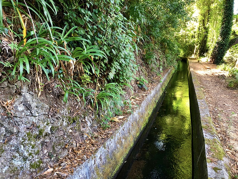
A pleasant walk along the Levada do Caniço, which flows from the centre of Camacha down towards the higher parts of Caniço village. Rich in fauna and flora, with typical island mountain plantations along the way. ⚠️ After heavy rain, do not attempt this walk — the levada can overflow onto the path, making it impossible to cross. Take care on narrow sections.
- Distance: 8.7 km (out & back) · Difficulty: Moderate · Duration: 3–3.5 h
- ⭐ 4.2★ from 71 hiker reviews on AllTrails
A longer variation that starts and ends in Camacha village, walking along part of the Levada do Caniço up to the highest areas of Caniço and back. Same rain-safety warning applies. This is the route most people mean when they talk about combining "Levada do Caniço – Levada dos Tornos – Ribeirinha" as a connected day hike.
- Distance: 11.7 km (out & back) · Difficulty: Hard · Duration: 5–5.5 h
- ⭐ 3.7★ from 36 hiker reviews on AllTrails
Community route note: The Levada do Caniço and Caniço Levada Trail are mapped on AllTrails but are not part of Madeira's official PR trail network managed by IFCN. They have no official open/closed status and no maintenance or signage guarantee — check access and conditions locally before going.
| Route | Type | Distance | Difficulty | Duration | Rating |
|---|---|---|---|---|---|
| PR 29 – Levada dos Tornos (Camacha) | Official PR | 13 km | Moderate | 4–5 h | 4.1★ (36) |
| Levada do Caniço | Community | 8.7 km | Moderate | 3–3.5 h | 4.2★ (71) |
| Caniço Levada Trail (Camacha) | Community | 11.7 km | Hard | 5–5.5 h | 3.7★ (36) |
- Best time: Mornings, when mist adds atmosphere — and the levada paths are less slippery.
- Footwear: Non-slip hiking boots are essential, especially in the rainy season when mini waterfalls cross the path.
- Rain warning: After heavy rain, these levadas can overflow directly onto the path. Don't attempt the Levada do Caniço sections in those conditions.
- Tunnel: PR 29 has a 400 m unlit tunnel — carry a headlamp (a phone torch is not enough).
- Getting there: The starting point for all three routes is near Camacha (~20 min drive from Funchal). Directions to PR 29 trailhead ↗
Would you like me to check the mountain forecast + IPMA weather warnings for the day you're planning to go, or show you how to get to Camacha by bus?