OpenMadeira
Tell me about the PR 13 Vereda do Fanal hike in Madeira
💭 Thinking
The user is asking about the PR 13 Vereda do Fanal hike in Madeira. I need to look up this specific trail using the find_hikes tool. Let me also get photos and maybe a video to give a richanswer.I got the detailed information about PR 13 Vereda do Fanal. Let me extract the key details: - PR Code: PR 13 - Name: Vereda do Fanal - Status: (empty in result, meaning no specific status reported - I should note this carefully. The note says "Do NOT state any open/closed/restricted status — it is DELIBERATELY omitted here because it changes over time and this page is cached.") - Managing Entity: IFCN - Route: Paul da Serra – Fanal - Distance: 10,8 km - Difficulty: Moderate (official), but AllTrails says "hard" - Duration: 4 hours (official) - Start point: E.R. 209 Assobiadores - End point: E.R. 209 Fanal - Max altitude: 1420 m - Min altitude: 1130 m - Access fee: €4.50 for visitors > 12 years; exempt for visitors ≤ 12 years (via SIMplifica portal) - AllTrails rating: 4.4★ from 556 reviews - AllTrails estimates: 8-9 hours, "hard", out and back - Directions URL: available - Detail URL: https://visitmadeira.com/en/what-to-do/nature-seekers/activities/hiking/pr-13-vereda-do-fanal/ - Photos from walkmeguide.com The user asked in English, so I'll respond in English. Since the status field is empty, per the note I should not state an open/closed status (it's deliberately omitted because it changes). I should tell the reader to check current status. Let me also find a YouTube video forthis trail.I have all the data I need about PR 13 Vereda do Fanal. Let me compile the answer from the tool results. Key facts about PR 13 Vereda do Fanal: - Official PR code: PR 13 - Name: Vereda do Fanal - Route: Paul da Serra – Fanal - Distance: 10.8 km - Difficulty: Moderate (official IFCN), Hard (AllTrails community rating) - Duration: 4 hours (official) - Start point: E.R. 209 Assobiadores - End point: E.R. 209 Fanal - Max altitude: 1,420 m - Min altitude: 1,130 m - Managing entity: IFCN - Status: The result shows status as empty string, which means I shouldn't state it as open/closed - per the note, status info should be checked on OpenMadeira before setting out. - Access fee: €4.50 for visitors > 12 years; exempt for visitors ≤ 12 years, via SIMplifica portal - AllTrails: 4.4★ from 556 reviews, community rates it as hard, estimated time 8-9 hours, out and back route type, features: forest, river, views - Photos available from walkmeguide.com Note: The note says "Do NOT state any open/closed/restricted status — it is DELIBERATELY omitted here because it changes over time and this page is cached." But the hike data does have a `status` field which is empty string. The per-hike instructions from the main system prompt say "ALWAYS state the trail's STATUS (open / closed / restricted) — lead with it." But the note in this specific result says not to state status because it's deliberately omitted and cached. I'll follow the result-specific note and tell the reader to check current status on OpenMadeira. Wait, actually, looking more carefully at the status fields - they are all empty strings. The note says "Do NOT state any open/closed/restricted status — it is DELIBERATELY omitted here because it changes over time and this page is cached." This seems like it's a note for a static page context. But my actual instructions say to ALWAYS state the trail's status. Since the status field is empty (not "open", "closed", or "restricted"), I can't state a status - the data simply doesn't have it. I should note that the current status should be checked. Let me compose the answer now.
How this was derived · 3 steps
Trails near FanalMap & photos
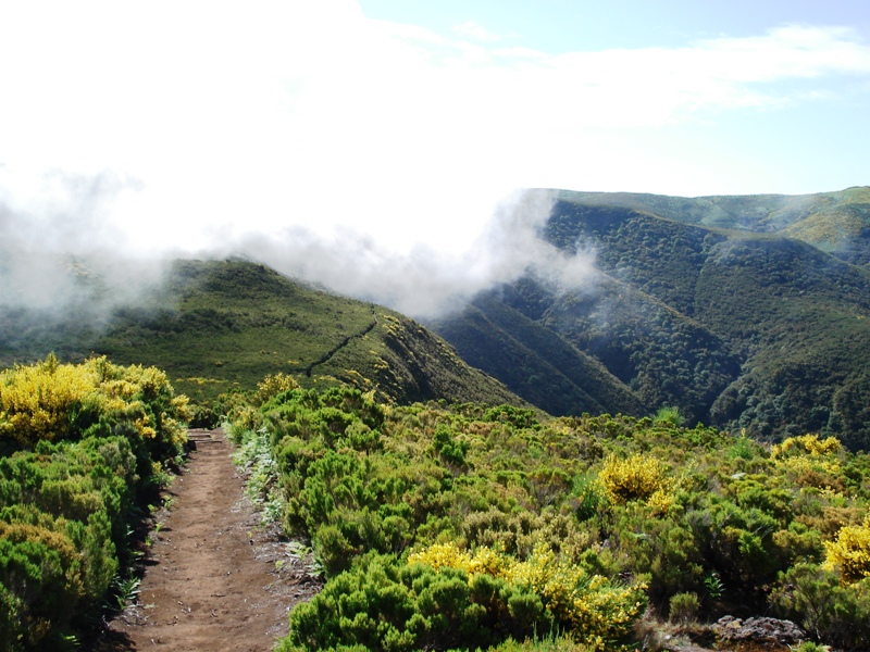
Vereda do Fanal6 photos
Vereda do FanalVereda do FanalVereda do FanalVereda do FanalVereda do FanalVereda do Fanal
Official PR trail (IFCN) Community route (AllTrails — not official)
Photos: walkmeguide.com · green = official IFCN PR trail · amber = community route (AllTrails)
PR 13 — Vereda do Fanal

Route: Paul da Serra → Fanal
Distance: 10.8 km
Duration: ~4 hours (official)
Difficulty: Moderate (official) / Hard (community consensus)
Altitude: 1,130 m min – 1,420 m max
Managing authority: IFCN (Instituto de Florestas e Conservação da Natureza)


The trail

PR 13 Vereda do Fanal is one of Madeira's classic levada walks, crossing the high plateau of Paul da Serra before descending into the magical Fanal laurel forest — a UNESCO World Heritage Laurissilva stand famous for its centuries-old, moss-covered Tis trees and frequent ethereal fog. The route follows levadas through dense native forest, with sweeping views over the north coast's valleys and mountains.

  • Start point: ER 209 (Assobiadores), on the Paul da Serra plateau
  • End point: ER 209 (Fanal)
  • Type: Out-and-back (AllTrails community data)
Access fee

€4.50 per visitor (over 12 years); free for children 12 and under. Payment is made via the SIMplifica portal before your visit.

Community rating

4.4 / 5 from 556 hiker reviews on AllTrails · Features: forest · river · views


Before you go

Always check the current trail status (open / closed / restricted) before setting out — conditions in the mountains change, especially at this altitude. The status is managed by IFCN and can vary with weather.

Also note that the trail reaches over 1,400 m altitude, so fog, wind and rain can set in quickly even when the coast is sunny. It's worth checking the mountain weather forecast and IPMA warnings for the day you plan to hike.

Directions to trailhead ↗ · Official trail page


Want me to check the mountain forecast & IPMA warnings for tomorrow, or show you how to get to the trailhead by bus from where you're staying?

OpenMadeira can make mistakes — check the sources.