Tell me about the Quatro Estrados - Camacha hike in Madeira
💭 Thinking
The user is asking about a specific hike called "Quatro Estrados - Camacha" in Madeira. Let me search for this trail using the find_hikes tool.The search returned no results for "Quatro Estrados Camacha". Let me try different search terms - maybe the trail name is different, or it's a community (non-PR) trail. Let me searchmore broadly.The user asked about the "Quatro Estrados - Camacha" hike, but our trail data doesn't have an exact match. Let me search more specifically for this trail name.The user is asking about "Quatro Estrados - Camacha" hike in Madeira. Based on my search results, I can see that:
1. There is no official PR trail called "Quatro Estrados" - it's not in the IFCN official trail register
2. From the web search, I can see references to "Sítio das Quatro Estradas" (also spelled "4 Estradas" or "Quatro Estradas") as a location/starting point near Camacha
3. The search results mention walks from "Sítio das Quatro Estradas" along the Levada dos Tornos to Camacha
4. There's an official PR trail called PR29 - Levada dos Tornos (Camacha) which is partially open, and it seems to be related to this area
5. From the AllTrails community results, there's "Camacha - Levada Dos Tornos" (22.4 km, hard, 4.1★ from 36 reviews) and "Caniço Levada Trail (Camacha)" (11.7 km, hard, 3.7★ from 36 reviews)
Let me also check - the "Quatro Estrados" might be a variant spelling of "Quatro Estradas". From the blog post, there's a walk described as "Levada Walk from Sitio das Quatro Estradas" along the Levada dos Tornos to Camacha, and from the Trailblazer guide, "Walk 5 - From Vale Paraíso to Camacha" starting from Sítio das Quatro Estradas.
The official PR29 - Levada dos Tornos (Camacha) is listed as "Partially Open" according to the web source. Let me check the find_hikes results more carefully.
In my initial find_hikes search near Camacha, one of the community trails was "Camacha - Levada Dos Tornos" (4.1★, 36 reviews, 22.4 km, hard, out and back). This is likely the closest match.
Let me also look at the PR29 information from the web search - it says PR29 - Levada dos Tornos (Camacha) is "Parcialmente aberto" (Partially Open), 13km.
Now, "Quatro Estrados" vs "Quatro Estradas" - the user wrote "Quatro Estrados" which seems like it could be a typo or variant of "Quatro Estradas" (Four Roads). The "Sítio das Quatro Estradas" is a specific locality in the Camacha area.
Let me also look for the community trail "Camacha - Levada Dos Tornos" which starts at the Camacha area and follows the Levada dos Tornos.
I also found from the Outdooractive result: "De Camacha até Sítio das Quatro Estradas" - a route from Camacha to Sítio das Quatro Estradas.
So the hike the user is asking about seems to be an unofficial route that goes from Sítio das Quatro Estradas (a crossroads location) along the Levada dos Tornos towards Camacha. This is not an official PR trail managed by IFCN, but rather a community/unofficial route.
Let me now find the video for this trail and prepare my answer.
Actually, I should be more careful here. The user said "Quatro Estrados" which might be a minor spelling variation. Let me search for it on YouTube to find a video.
Let me also check: from the find_hikes results near Camacha, the "Camacha - Levada Dos Tornos" community trail has:
- Rating: 4.1★ from 36 reviews
- Difficulty: hard
- Length: 22.4 km
- Route type: out and back
- Estimated time: 6.5–7.5 hr
- Description mentions starting next to Igreja Matriz da Camacha and walking along the Levada dos Tornos
And the PR29 - Levada dos Tornos (Camacha) from the web search is:
- 13 km
- Moderate
- Partially Open
- Fee: €4.50
Let me provide a comprehensive answer. The walk the user is asking about - "Quatro Estrados - Camacha" - is essentially a walk along the Levada dos Tornos from Sítio das Quatro Estradas to Camacha (or vice versa). This corresponds to part of the official PR29 trail and the community route mapped on AllTrails.
Wait - I notice the find_hikes search for "Quatro Estrados" returned no results. And the search for hikes near Camacha returned community trails but the "Camacha - Levada Dos Tornos" is listed there.
Let me provide a good answer combining the information Ihave.The user is asking about the "Quatro Estrados - Camacha" hike in Madeira. Let me analyze what I've found:
1. The official trail network (IFCN) doesn't have a trail called "Quatro Estrados" or "Quatro Estradas" in our database.
2. From the web search, I found that:
- "Sítio das Quatro Estradas" (also written as "4 Estradas" or "Quatro Estradas") is a location/crossroads in the Camacha area
- There's a walk from "Sitio das Quatro Estradas" along the Levada dos Tornos to Camacha — this appears in the Rother Walking Guide as walk nr 15
- The Trailblazer guide describes "Walk 5: From Vale Paraíso to Camacha" starting at "Sítio das Quatro Estradas" — 5.2 km, 1:30 hrs
- There's also PR 29 - Levada dos Tornos (Camacha) which is 13 km, partially open
- The community trail on AllTrails: "Camacha - Levada Dos Tornos" — 22.4 km, hard, 4.1★ from 36 reviews
3. The "Quatro Estrados" spelling seems to be a variant of "Quatro Estradas" (Four Roads) — it's a location name (crossroads) near Camacha where several roads meet.
4. From the web results, this appears to be a walk along the Levada dos Tornos from Sítio das Quatro Estradas down to Camacha. The Levada dos Tornos is one of the most important water channels on Madeira, over 100 km long.
Let me look at the community trail data I already have:
- "Camacha - Levada Dos Tornos" — 22.4 km, hard, 4.1★ from 36 reviews, not official IFCN PR trail
And PR 29 also exists as a separate official trail.
From the AllTrails community data near Camacha, I don't see an exact match for "Quatro Estrados - Camacha" but I have "Camacha - Levada Dos Tornos" which is related.
Let me also check the Outdooractive result which mentions "De Camacha até Sítio das Quatro Estradas" — a 14.7 km route, T3 difficulty, 4:30h.
The blog post describes a walk from Quatro Estradas along Levada dos Tornos to Camacha — it mentions steep sections, vertiginous parts where the levada is carved into steep cliffs, and it took about 5 hours (1120 to 1700).
So: "Quatro Estrados - Camacha" is a walk along the **Levada dos Tornos** from **Sítio das Quatro Estradas** (a crossroads/intersection) to **Camacha**. It's NOT an official IFCN PR trail with that name — it's a common walking route using the levada path.
PR 29 is officially called "Levada dos Tornos (Camacha)" and is a related official trail.
The community trail I have is "Camacha - Levada Dos Tornos" from AllTrails (22.4 km, hard, 4.1★, 36 reviews).
Let me provide a helpful answer combining what I know from the web search and the community trail data. I should note it's not an official IFCN PR trail named "Quatro Estrados" but rather a walk along the Levada dos Tornos starting from the Sítio das Quatro Estradas crossroads.
Now let me also get the current status of PR 29 since the web search showed it as "Parcialmente aberto" (partially open). But I don't have PR 29 in our official database from find_hikes. Let me check once more with a different query.
Actually, I already tried "PR 29 Levada dos Tornos Camacha" and got 0 results. And the broader search for "Quatro Estrados" also returned 0 official hikes. The madeirahiking.org site lists PR 29 as partially open, 13km.
Let me compose the answer now. The key facts:
- "Quatro Estrados" (properly "Quatro Estradas" = "Four Roads") is a crossroads location near Camacha
- The walk from Quatro Estradas to Camacha follows the **Levada dos Tornos**
- There's an official trail PR 29 "Levada dos Tornos (Camacha)" — 13 km, currently **partially open**
- The AllTrails community trail "Camacha - Levada Dos Tornos" is 22.4 km, rated hard, 4.1★ from 36 reviews
- The route features woodland, eucalyptus forest, laurel forest (Laurisilva), vertiginous sections carved into cliffs, and views
- The Rother/Trailblazer guide describes a shorter version: from Vale Paraíso / Quatro Estradas to Camacha — about 5.2 km, 1.5 hours
- The longer version (Quatro Estradas to Camacha along the full levada) is about 13-14.7 km
I should tell the user about both the official PR 29 and the community route, and clarify what "Quatro Estrados" refers to.
Let me also look up what the curated video data shows - I already have community trails near Camacha including "Camacha - Levada Dos Tornos".
Now for the answer. I'll note:
1. "Quatro Estrados" = "Quatro Estradas" (Four Roads) — a crossroads/location, not a trail name
2. The walk is along the Levada dos Tornos
3. Official PR 29 "Levada dos Tornos (Camacha)" — partially open, 13 km
4. Community trail info from AllTrails
5. Description and highlights from the web sources
6. Howto get there
Photos: walkmeguide.com · green = official IFCN PR trail · amber = community route (AllTrails)
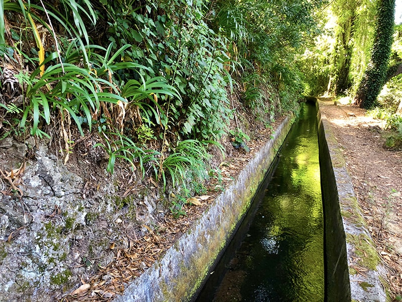
The Quatro Estradas–Camacha walk isn't the name of an official PR trail — "Quatro Estradas" (Four Roads, sometimes written "Quatro Estrados") is the crossroads location near Camacha where several roads meet. The walk itself follows the Levada dos Tornos, one of Madeira's longest and most important irrigation channels (over 100 km in total).
Here's what you need to know:
Official trail: PR 29 – Levada dos Tornos (Camacha)
PR 29 is the official IFCN-classified trail covering this levada. It's currently partially open — some sections may be inaccessible, so check the current status before setting out (IFCN status page).
Community route: Camacha – Levada dos Tornos (AllTrails)
This is the broader AllTrails-mapped route covering the levada area around Camacha:
Length
22.4 km
Difficulty
Hard
Route type
Out and back
Rating
4.1★ from 36 hiker reviews
Status
⚠️ Community route — not part of Madeira's official PR trail network managed by IFCN, so it has no official open/closed status
Starting from Sítio das Quatro Estradas (the crossroads on the ER-202 road between Santo da Serra and Poiso pass, ~870 m altitude), you join the Levada dos Tornos and follow it westward through:
Eucalyptus and mixed forest in the upper sections
Laurisilva (laurel forest) further along — Madeira's native UNESCO-listed woodland
Vertiginous cliffside sections where the levada is carved into steep hillsides — not suitable for anyone with a fear of heights
Wild passion-fruit vines (maracujá) lining the path in season
Views across the valleys and toward the south coast
The classic shorter version (Quatro Estradas → Camacha via the levada) is roughly 5–6 km / 1.5–2 h one way, descending gently to Camacha village. A longer version continues along the levada towards Vale Paraíso and beyond.
Established walking guides (Rother, Trailblazer) describe it as walk #15 and "Walk 5 – Vale Paraíso to Camacha" respectively, both starting from the Quatro Estradas crossroads.
Getting there
By car: Park near the Quatro Estradas crossroads on the ER-202 (between Santo da Serra and Poiso)
By bus: Horários do Funchal line 77 serves the "4 Estradas" stop from Funchal (limited schedule — check times). From Camacha village, bus 129 runs back to Funchal
⚠️ Important notes
The levada path has narrow, exposed sections carved into cliff faces — vertigo sufferers should avoid it
After heavy rain, sections can be wet and slippery; wear proper non-slip footwear
The route is partially open under the official PR 29 designation — check current status before you go
Carry a torch for any short tunnel sections
Want me to check the mountain weather forecast and IPMA warnings for the day you're planning to go, or find the closest bus connections to the trailhead?
OpenMadeira can make mistakes — check the sources.