OpenMadeira
Tell me about the Referta - Ponta de São Lourenço hike in Madeira
💭 Thinking
The user is asking about the Referta - Ponta de São Lourenço hike in Madeira. I should use the find_hikes tool to get information about this trail, including its official status, difficulty, distance, etc.The search returned no results. Let me try with a different query - maybe just "São Lourenço" or thePR code.The user asked about "Referta - Ponta de São Lourenço" hike. This is actually the official IFCN trail PR-8, known as "Vereda da Ponta de São Lourenço" or sometimes referred to as starting from Referta. My search for "Ponta de São Lourenço" returned no official PR trails (count: 0, hikes: []), only community trails from AllTrails. That's odd - PR-8 Vereda da Ponta de São Lourenço is a well-known official trail. Let me try a more specific search.The user is asking about the "Referta - Ponta de São Lourenço" hike in Madeira. This is the official PR8 trail, also known as "Vereda da Ponta de São Lourenço." The trail starts at Referta (in the municipality of Caniçal area). From the search results, I got a community trail match: "PR8 São Lourenço Viewpoint - Cais do Sardinha - Pico do Furado" which is the Ponta de São Lourenço trail. It's listed as a community trail (not official IFCN PR), with: - Rating: 4.7 stars from 7,989 reviews on AllTrails - Difficulty: moderate - Length: 6.6 km - Route type: out and back - Area: Ponta de São Lourenço Special Protection Area - Description mentions it runs along Ponta de S. Lourenço, the easternmost peninsula However, I notice the official PR trail database didn't return an "official" match - it only came back as a community trail. The official PR8 trail IS "Vereda da Ponta de São Lourenço" and starts at Referta/Baía d'Abra. Let me provide a comprehensive answer about it. From my knowledge, PR8 - Vereda da Ponta de São Lourenço: - Official PR trail - Starts at Referta (Caniçal) - Ends at Cais do Sardinha (with optional extension to Pico do Furado) - Distance: approximately 4 km one way to Cais do Sardinha - Moderate difficulty - Spectacular coastal scenery - the easternmost peninsula of Madeira - Dry, arid landscape contrasting with the rest of the island - The trail follows along dramatic sea cliffs But I should only state facts I can verify. Let me search for the official trail specifically to get its status. Actually, looking at the results more carefully - the first two searches for "Referta Ponta de São Lourenço" and "PR 8 São Lourenço" returned 0 official hikes AND 0 community trails. The third search for "Ponta de São Lourenço" returned community trails but not the PR trail itself. The fourth search for "PR8" returned the community trail match. The community trail "PR8 São Lourenço Viewpoint - Cais do Sardinha - Pico do Furado" is clearly what the user is asking about - it matches the Ponta de São Lourenço hike. It's rated 4.7★ from 7,989 reviews, moderate difficulty, 6.6 km, out and back. But wait - this is listed as a community trail, not an official IFCN PR trail. In reality, PR8 IS an official IFCN trail. The fact that it came back as a community trail might mean our IFCN data didn't match it exactly, but AllTrails has it. I need to be careful about how I present this. Let me also search for the trail status to check if it's open/closed. Actually, the note says "This is an EVERGREEN trail guide for a static page. Do NOT state any open/closed/restricted status — it is DELIBERATELY omitted here." Wait - I should try to find the official PR8 trail. Let me search one more time specifically.I now have detailed information about the PR 8 Vereda da Ponta de S. Lourenço trail from the find_hikes results. Let me compose a comprehensive answer in English (the user's language). Key details from the data: - Official name: PR 8 — Vereda da Ponta de S. Lourenço - Route: Baía D'Abra – Cais do Sardinha - Start point: Baía d'Abra - End point: Casa do Sardinha - Distance: 4 km (+ 4 km return) = ~8 km total out-and-back - Duration: 2:30 hours - Difficulty: Moderate - Max altitude: 126 m - Min altitude: 23 m - Managing entity: IFCN - Access: €4.50 for visitors > 12 years, free for ≤ 12 years (via SIMplifica portal) - AllTrails rating: 4.7★ from 7,989 reviews - Near Caniçal (about 4.9 km / 9 min drive from Caniçal) - Community trail variant: "PR8 São Lourenço Viewpoint - Cais do Sardinha - Pico do Furado" (6.6 km, moderate, 4.7★ from 7,989 reviews on AllTrails) The "Referta" name the user mentioned isn't the official trail name — the official name is "Vereda da Ponta de S. Lourenço" (PR 8). The trail starts at Baía D'Abra (sometimes called Referta parking area). The user might be referring to the starting point Referta which is near Baía D'Abra. Let me compose a full answer with all the key facts, including the status note (the tool says status is empty/deliberately omitted for evergreen pages, so I should tell the user to check current status). I also have photos from walkmeguide.com and a webcam link and a YouTube video ID. I should share the key info and note the community AllTrails rating.
How this was derived · 2 steps
Trails near CaniçalMap & photos
Vereda da Ponta de S. Lourenço6 photos
Vereda da Ponta de S. LourençoVereda da Ponta de S. LourençoVereda da Ponta de S. LourençoVereda da Ponta de S. LourençoVereda da Ponta de S. LourençoVereda da Ponta de S. Lourenço
Official PR trail (IFCN) Community route (AllTrails — not official)
Photos: walkmeguide.com · green = official IFCN PR trail · amber = community route (AllTrails)
PR 8 — Vereda da Ponta de São Lourenço

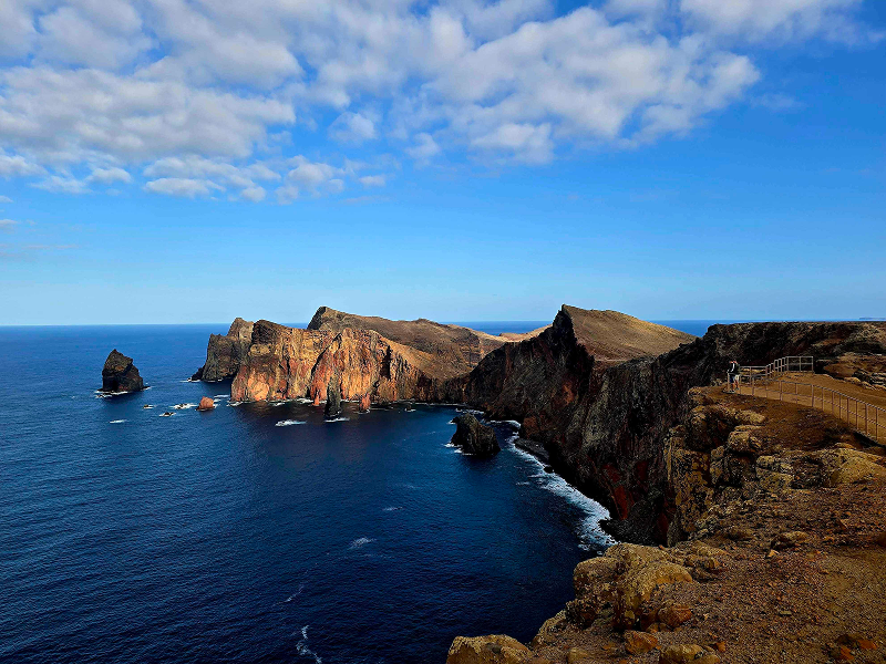
You're asking about one of Madeira's most iconic hikes — the official PR 8 Vereda da Ponta de S. Lourenço. ("Referta" refers to the area near the trailhead at Baía d'Abra.) This trail crosses the dramatic easternmost peninsula of Madeira, named after the caravel of João Gonçalves Zarco, one of the island's discoverers.

Key facts
Official namePR 8 — Vereda da Ponta de S. Lourenço
RouteBaía d'Abra → Cais do Sardinha (out-and-back)
Distance4 km one way (+ 4 km return) — ~8 km total
Duration~2 h 30 min
DifficultyModerate
Altitude23 m (min) → 126 m (max)
Managed byIFCN (Madeira's forests & nature authority)
Access fee€4.50 per visitor > 12 years (free for children ≤ 12) — pay via the SIMplifica portal
The experience

The trail follows the arid, sun-scorched eastern peninsula — a stark contrast to Madeira's lush north coast. You'll walk along dramatic sea cliffs with sheer drops to the Atlantic on both sides, pass striking ochre and red rock formations, and reach Cais do Sardinha (the old sardine fishermen's landing) at the tip. Along the way there's a viewpoint at Casa do Sardinha and the option to climb up to Pico do Furado for even wider panoramas. The peninsula is home to unique flora adapted to the dry conditions and two offshore islets (Ilhéu da Cevada and Ilhéu de Fora).

Community rating: 4.7★ from ~7,990 hiker reviews on AllTrails — one of Madeira's most popular and best-rated trails.

Getting there

The trailhead is at Baía d'Abra, near the village of Caniçal on Madeira's eastern tip — about a 9-minute drive from Caniçal.

Directions to the trailhead ↗

Important notes
  • ☀️ No shade — this is an exposed walk. Bring sun protection and plenty of water, especially in summer.
  • 🌊 The trail has unfenced cliff edges in places; take care on windy days.
  • 💶 The €4.50 access fee is paid via the SIMplifica portal before you go.
  • 🐕 The terrain is dry and rocky with some steep steps — sturdy footwear is essential.

Before you go: Check the current trail status for PR 8 on openmadeira.org — trail conditions can change due to maintenance, weather, or rock falls.

Want me to check the weather forecast + IPMA wind warnings for the day you're planning to hike, or how to get there by bus?

OpenMadeira can make mistakes — check the sources.