Tell me about the Vereda do Larano - Boca do Risco - Vereda do Caniçal - Pico do Facho hike in Madeira
💭 Thinking
The user is asking about a specific hike in Madeira - "Vereda do Larano - Boca do Risco - Vereda do Caniçal - Pico do Facho". This seems to be a combination of trails. Let me search for information about these trails using the find_hikes tool.
I'll search for the individual trails as well as the combined route name.The user is asking about "Vereda do Larano - Boca do Risco - Vereda do Caniçal - Pico do Facho" which is a combined route linking multiple paths in the Caniçal/Machico area of Madeira.
Looking at the results, there are no official IFCN PR trails that match this exact combined route. However, several community (AllTrails) routes match parts of it:
1. **"Caniçal's Levada - Larano Footpath"** — 4.7★, 398 reviews, hard, 26.6 km, out and back, ~12-13 hr — This seems to match the full Larano + Caniçal levada combination.
2. **"Rota das Veredas da Boca do Risco e Larano"** — 4.7★, 180 reviews, hard, 10.1 km, point to point — This matches the Boca do Risco + Larano section.
3. **"Vereda Boca do Risco Caniçal - Pico das Roçadas - Levada do Caniçal"** — 4.4★, 581 reviews, moderate, 6.9 km, loop — This includes Boca do Risco + Caniçal + Pico das Roçadas.
4. **"Vereda Boca do Risco Caniçal - Levada do Caniçal"** — 4.7★, 168 reviews, hard, 14.6 km, loop, ~6-6.5 hr — Boca do Risco + Levada do Caniçal.
5. **"Vereda da Boca do Risco - Vereda do Larano - Praia da Malata"** — 4.9★, 132 reviews, hard, 22 km, out and back, ~11-12 hr — This links Boca do Risco + Larano + Praia da Malata.
6. **"Pico do Facho - Machico Beach - Nossa Senhora do Amparo Fort"** — 4.4★, 171 reviews, hard, 4.2 km, loop, ~2.5-3 hr — This is the Pico do Facho section.
The user's query "Vereda do Larano - Boca do Risco - Vereda do Caniçal - Pico do Facho" seems to be a long combined route that links several of these community paths. The closest single community route is "Caniçal's Levada - Larano Footpath" (26.6 km), but that's only the Larano + Levada do Caniçal portion.
The user's combined route appears to be a mega-route stitching together:
- Vereda do Larano
- Boca do Risco
- Vereda do Caniçal (Levada do Caniçal)
- Pico do Facho
This is a community/unofficial combination — no single official PR trail covers all of this. I should present the relevant community trails and explain the combined route, noting they are community routes (not official IFCN PR trails).
Let me present the relevant community trails that correspond to sections of this combined route, focusing on the ones that match the user's query most closely.
The most relevant ones are:
1. **Caniçal's Levada - Larano Footpath** — the full Larano + Levada do Caniçal combo (26.6 km, hard, 4.7★)
2. **Rota das Veredas da Boca do Risco e Larano** — Boca do Risco + Larano (10.1 km, hard, 4.7★)
3. **Vereda Boca do Risco Caniçal - Pico das Roçadas - Levada do Caniçal** — Boca do Risco + Caniçal + Pico das Roçadas (6.9 km, moderate, 4.4★)
4. **Vereda da Boca do Risco - Vereda do Larano - Praia da Malata** — Boca do Risco + Larano + Malata (22 km, hard, 4.9★)
5. **Pico do Facho - Machico Beach - Nossa Senhora do Amparo Fort** — Pico do Facho section (4.2 km, hard, 4.4★)
I should focus on the ones that most directly match the user's combined route. The "Caniçal's Levada - Larano Footpath" at 26.6 km seems closest to the full combined route the user is asking about, though it doesn't include Pico do Facho or Boca do Risco explicitly.
Actually, let me re-read the user's question: "Vereda do Larano - Boca do Risco - Vereda do Caniçal - Pico do Facho" — this seems to be listing all the segments they want to combine.
The AllTrails community routes that correspond to sections:
- **Rota das Veredas da Boca do Risco e Larano** (10.1 km) — covers Boca do Risco + Larano
- **Vereda Boca do Risco Caniçal - Levada do Caniçal** (14.6 km) — covers Boca do Risco + Levada do Caniçal
- **Pico do Facho loop** (4.2 km) — covers Pico do Facho
- **Caniçal's Levada - Larano Footpath** (26.6 km) — the big combo
There's no single community trail that combines ALL four segments the user mentions. The most comprehensive one is "Caniçal's Levada - Larano Footpath" at 26.6 km, but it may not include Pico do Facho.
I'll present the key community routes and explain how the user's desired combined route relates to them, noting these are unofficial community routes.
Let me also find a YouTube video ofthis trail.The user asked about "Vereda do Larano - Boca do Risco - Vereda do Caniçal - Pico do Facho" hike. This is not one of the official IFCN PR trails — it's a community route. Looking at the community_trails results, the closest matches are:
1. "Caniçal's Levada - Larano Footpath" — 4.7★, 398 reviews, hard, 26.6 km, out and back
2. "Rota das Veredas da Boca do Risco e Larano" — 4.7★, 180 reviews, hard, 10.1 km, point to point
3. "Pico do Facho - Machico Beach - Nossa Senhora do Amparo Fort" — 4.4★, 171 reviews, hard, 4.2 km, loop
4. "Vereda Boca do Risco Caniçal - Levada do Caniçal" — 4.7★, 168 reviews, hard, 14.6 km, loop
5. "Vereda da Boca do Risco - Vereda do Larano - Praia da Malata" — 4.9★, 132 reviews, hard, 22.0 km, out and back
6. "Vereda Boca do Risco/Caniçal - Pico das Roçadas - Levada do Caniçal" — 4.4★, 581 reviews, moderate, 6.9 km, loop
7. "Rota da Boca do Risco - Levada do Canical" — 4.5★, 106 reviews, hard, 13.5 km, loop
8. "Pico das Roçadas Trail" — 4.4★, 119 reviews, moderate, 3.9 km, loop
The name "Vereda do Larano - Boca do Risco - Vereda do Caniçal - Pico do Facho" suggests a longer combined route that goes through all these segments. The closest match from the community trails is probably "Caniçal's Levada - Larano Footpath" at 26.6 km, which encompasses the Larano section and the Levada do Caniçal.
But actually, looking more carefully at the user's query, they're naming a combined route that strings together multiple trail sections:
- Vereda do Larano (the Larano coastal path)
- Boca do Risco (the viewpoint/section between Larano and Caniçal)
- Vereda do Caniçal (the levada path near Caniçal)
- Pico do Facho (the peak near Machico)
This is essentially a long combined route that several of these community trails cover in different configurations. The "Caniçal's Levada - Larano Footpath" at 26.6 km seems to be the one that most closely matches the full route described.
Let me provide a comprehensive answer about this hike, noting it's a community route (not an official IFCN PR trail), drawing from the relevant community trail data.
I should focus on the most relevant matches. The name the user gave covers multiple connected segments. The best match is "Caniçal's Levada - Larano Footpath" (26.6 km, rated 4.7★ with 398 reviews) which combines the Levada do Caniçal and Vereda do Larano. But the user also mentions Boca do Risco and Pico do Facho.
The "Rota das Veredas da Boca do Risco e Larano" (10.1 km) covers Boca do Risco and Larano. The "Pico do Facho" trail (4.2 km) covers Pico do Facho separately.
I think the best approach is to explain this is a combined community route (not an official PR trail), describe the key sections based on the community data, and point to the relevant AllTrails pages.
Let me craft a thorough answer.
Official PR trail (IFCN) Community route (AllTrails — not official)
Rota das Veredas da Boca do Risco e Larano 4.7 Directions
Photos: walkmeguide.com · green = official IFCN PR trail · amber = community route (AllTrails)
The Vereda do Larano – Boca do Risco – Vereda do Caniçal – Pico do Facho route is a community-mapped hike on Madeira's dramatic east coast — it's not one of the official IFCN PR trails, but rather a longer combined route that strings together several iconic segments along the cliffs and levadas near Machico and Caniçal. Here's what you need to know:
⚠️ Important — Unofficial trail
This is a community route mapped on AllTrails — not part of Madeira's official PR (Percurso Recomendado) trail network managed by IFCN, the regional government's forests and nature-conservation authority. That means it has no official open/closed status, no guaranteed signage or maintenance, and no fee booth. Check access and conditions locally before heading out.
The key segments
The name you gave covers several connected sections. Here are the closest-matched community trails, with their AllTrails ratings:
Vereda do Larano — The stretch from Porto da Cruz area along the spectacular north-coast cliffs. Narrow in places, with breathtaking ocean views and dramatic drops. The path hugs the cliffside — stunning but requires a head for heights and sure footing.
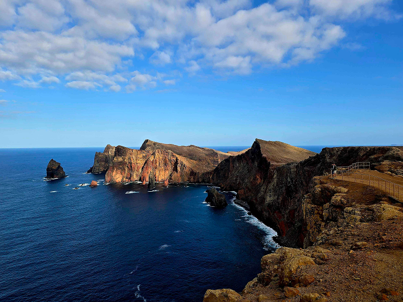
Boca do Risco — One of the most beautiful natural viewpoints on the island's east side. You reach it through agricultural fields and small exotic forests. From the viewpoint, the path can branch towards Caniçal or towards Porto da Cruz (the Larano direction). The westward (Larano) section is particularly exposed and can be risky — extra caution is needed.
Vereda do Caniçal (Levada do Caniçal) — Follows the old irrigation channel above Caniçal, once used to water crops and now a Levada walking path. This section offers clear views over Caniçal and the surrounding agricultural landscape, with the path running along a watercourse.
Pico do Facho — The peak north of Machico, accessible via a path near the Caniçal tunnel. Historically, bonfires were lit here to warn of approaching enemy ships. The summit viewpoint gives wide panoramic views over the Machico valley, the central peaks, the Desertas Islands, and Ponta de São Lourenço.
Practical info
Total distance: depends on the exact combination — the full Larano + Boca do Risco + Levada do Caniçal route (Caniçal's Levada – Larano Footpath) is ~26.6 km (out & back); the Boca do Risco + Larano section alone is ~10.1 km
Difficulty: Hard — narrow cliff paths, significant elevation change, and exposed sections
Estimated time: plan 6–13 hours depending on how much of the route you cover
No access fee (it's not an IFCN trail, so no SIMplifica payment required)
Several sections are narrow cliffside paths with steep drops — not suitable if you're uncomfortable with heights
The Larano stretch towards Boca do Risco can be particularly risky — proceed with caution
No official open/closed status — check locally for fallen rocks, erosion, or landslides after heavy rain
Bring plenty of water and sun protection — much of this route is fully exposed
Tell someone your plan and carry a charged phone
Would you like me to check the mountain weather forecast and IPMA warnings for the day you're planning to hike, or show you the nearest official IFCN trails in this area as alternatives?
OpenMadeira can make mistakes — check the sources.